


Slayden Voting District, Marshall County, Mississippi
About
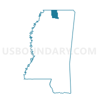
Outline

Summary
| Unique Area Identifier | 606252 |
| Name | Slayden Voting District |
| County | Marshall County |
| State | Mississippi |
| Area (square miles) | 38.54 |
| Land Area (square miles) | 38.52 |
| Water Area (square miles) | 0.02 |
| % of Land Area | 99.96 |
| % of Water Area | 0.04 |
| Latitude of the Internal Point | 34.93201730 |
| Longtitude of the Internal Point | -89.44891270 |
Maps


Graphs
Select a template below for downloading or customizing gragh for Slayden Voting District, Marshall County, Mississippi


Neighbors
Neighoring Voting District (by Name) Neighboring Voting District on the Map
- 12 Rossville Voting District, Fayette County, TN
- 16 Moscow Voting District, Fayette County, TN
- Early Grove Voting District, Marshall County, MS
- Hudsonville Voting District, Marshall County, MS
- Mt. Pleasant Voting District, Marshall County, MS
- N. Holly Springs Dist. 2, Marshall County, MS
Top 10 Neighboring County Subdivision (by Population) Neighboring County Subdivision on the Map
- District 2, Marshall County, MS (7,489)
- District 5, Fayette County, TN (5,603)
- District 7, Fayette County, TN (4,692)
Top 10 Neighboring Unified School District (by Population) Neighboring Unified School District on the Map
- Fayette County School District, TN (38,413)
- Marshall County School District, MS (25,068)
- Holly Springs School District, MS (12,076)
Top 10 Neighboring State Legislative District Lower Chamber (by Population) Neighboring State Legislative District Lower Chamber on the Map
- State House District 94, TN (70,412)
- State House District 13, MS (23,868)
- State House District 5, MS (23,098)
Top 10 Neighboring State Legislative District Upper Chamber (by Population) Neighboring State Legislative District Upper Chamber on the Map
Top 10 Neighboring 111th Congressional District (by Population) Neighboring 111th Congressional District on the Map
Top 10 Neighboring Census Tract (by Population) Neighboring Census Tract on the Map
- Census Tract 9503, Marshall County, MS (7,138)
- Census Tract 9501, Marshall County, MS (6,699)
- Census Tract 606, Fayette County, TN (4,072)
- Census Tract 607.01, Fayette County, TN (2,242)